Introduction:
In the month of June I participated in the BYPASS LAB, a one week workshop organised by the Indo-German Centre for Sustainability (IGCS), IIT Madras and hosted by the Rajiv Gandhi National Institute of Youth Development (RGNIYD) at Sriperumbudur. The workshop used a combination lectures and practical exercises to train early professionals and students on data gathering, data visualization and design research.
Programmes at the workshop
The workshop began with, Karl Beelen, an urban designer and research scholar at IGCS, introducing us to some various aspects that are bypassed in the peri-urban areas, such as infrastructure like basic transport facilities, bridges and bypasses. Durganand Balsavar an architect, activist and writer spoke about “investigating desolate peripheries” about the potential underlies (that is the capacity of Sriperumbudur to become a major city and to serve the needs of Chennai) in Sriperumbudur, which is undergoing a rapid rate of urbanisation. Deepta Sateesh, the Dean of the School of New Humanities and Design at Srishti Institute of Art, Design and Technology, demonstrated how the data can be visualised in ways different from the usual way of representation.
In the evening participants were given the task of identifying a place or an object, to visualise with respect to five different aspects, time - how an object reacts with respect to different time , scale - different sizes we can represent an object, practice - the act performed by the object, relationship - how the object relates itself with the place and time and places - to represent the place where the object is placed. After the exercise participants were taken to the field trip to Chembarambakkam Lake and areas around, to make us observe the various things happening around the rural and peri-urban area of Sriperumbudur.
Image 1: Visualisation with respect to 5 different aspects
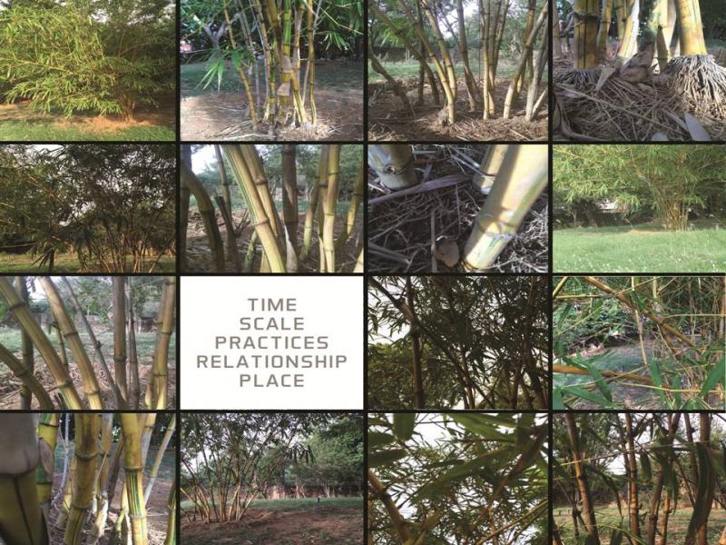
In this picture I represented a bamboo plant with respect to the five different aspects, time - how the bamboo reacts in different times: scale represents how it is seen from different scales of view; practice represents the act of growing of the plant; relationship - each bamboo were sprouted together but when time passes they grow and the distance between them increases; the place where the plants in this case it is the garden of RGNIYD.
On day 2, Seetha Raghupathy a senior urban designer from Singapore spoke about how maps can be made through a bottom-up approach with public participation. After the lecture, participants were allowed to take a field trip to the areas around Sriperumbudur, and come out with a theme for the project and strategy to proceed with the project, and present to get comments and suggestions from the mentors.
On day 3, Mapbox conducted a hands-on mapping session where they gave an overview of crowdsourced mapping and different online mapping platforms such as Mapillary, Field papers, Mapbox and Open Street Map.
The next day, the participants were allowed to take field trip and asked to present the theme and objective of the project, by incorporating the suggestion we got from the day. After that all groups had made presentations on their chosen theme and objective of their projects, we had a discussion on maps and map-making by Siddharth Hande, during which he demonstrated how maps are an important source of studying history and development.
The following day Kiran Keswani presented “Mapping the Everyday city”. Kiran is a doctoral student of Urban Design in the Faculty of Architecture, CEPT. She presented case studies on the negotiations happening in between cattles and peoples in the streets of a marketplace in Ahmedabad and the activities of the tea sellers in the marketplace to demonstrate how mapping can reveal everyday activities in our surroundings.
On the sixth day, we had a presentation by Arunava Dasgupta, the Head of the Department of Urban Design, School of Planning and Architecture, New Delhi. He presented his study on the villages of Himachal Pradesh on how the rural areas are adopting to the urban style of architecture and techniques that are significantly deviating from the local traditional practices.
Conclusion
This workshop came to me as an experience, different from usual by meeting with peoples from different background, students and professionals of architecture, urban design, students of developmental studies. I had a chance to explore the peri-urban chennai, its few industrial areas and the developments coming around it. The teachings from the lecture can be used in the day to day activities to understand what is happening and how it is happening through the mapping and it made me to think about how maps are important. Maps are one of the source which can be used to visualize, study, analyze in any field. This workshop has once again asserted this fact.
Add new comment