Coastlines have shaped human history as routes of exploration, trade, and community. Today, more than 40% of the world's population lives within 100 km of the coast, making coastal regions among the most densely populated and economically significant areas on Earth. Their ecosystems, including mangroves, coral reefs, estuaries, and wetlands, provide critical services by buffering storms, supporting fisheries, storing carbon, and sustaining local economies and cultures.
Yet these coasts face severe and accelerating pressure. Mangroves have lost 20–35% of their global extent over 50 years, 14% of coral reefs have been lost since 2009, and the 2023–2025 bleaching event affected 84% of reefs worldwide. Only 15% of coastlines remain in a near-natural state. Urbanisation, pollution, and climate change are transforming these landscapes faster than governments can respond.
Current governance approaches, policies, spatial planning, scientific assessments, and technological tools provide a strong foundation, but often leave limited space for the lived experiences, place values, and traditional knowledge of communities who interact with the coast every day. Rather than viewing this as a limitation alone, it presents an opportunity to strengthen coastal governance by bringing community knowledge into conversation with scientific evidence. Effective coastal governance must go beyond data, recognising place-based values and integrating local knowledge with science to produce decisions that are ecologically sound, socially just, and genuinely resilient.
Understanding People, Place, and Coastal Values
Maps are fundamental to coastal governance, guiding spatial planning, delineating coastal zones, identifying sensitive ecosystems, and informing policy decisions. They tell us where coastlines, habitats, and human activities are located. Yet for all their value, maps rarely capture what these places mean to the people who live, work, and depend on them.
Although maps represent the physical coastline, they cannot fully capture the social, cultural, ecological, and livelihood values that make the coast a living landscape for the communities who depend on it. These relationships are expressed through place values - the meanings, experiences, and benefits that individuals and communities associate with a place. Place values extend beyond ecological functions to encompass cultural, social, historical, recreational, spiritual, and livelihood dimensions. For coastal communities, fishing grounds, mangrove forests, estuaries, and wetlands are not simply natural resources; they are spaces that sustain livelihoods, preserve traditions, support biodiversity, and foster identity and belonging across generations.
Recognising place values broadens coastal governance from managing physical resources to understanding the relationships people have with them. When planning and decision-making acknowledge these diverse values, governance becomes more inclusive, context-specific, and responsive to local realities and creates space to integrate community perspectives alongside scientific evidence, laying the foundation for more holistic and people-centred coastal governance.
From Generations of Knowledge to Better Governance
For generations, coastal communities have developed a deep understanding of the sea's rhythms, commonly referred to as Traditional Knowledge Systems (TKS): a body of ecological knowledge rooted in continuous interaction with the coast. This knowledge shapes how communities interpret tidal cycles, track fish migration, protect mangroves, identify erosion zones, and respond to changing weather. It is place-based, adaptive, and built over lifetimes of observation. Across Tamil Nadu's 1,076 km coastline, these practices are not historical relics; they continue to guide how many communities interact with and manage coastal ecosystems today, as illustrated below.
Scientific tools—GIS, remote sensing, and climate models—provide valuable large-scale insights, but their effectiveness can be significantly strengthened when paired with this lived experience. Up to 80% of global fish catches depend directly or indirectly on mangrove ecosystems, yet decisions about these ecosystems are routinely made fully incorporating the knowledge of the communities who know them best. Integrating traditional knowledge with scientific evidence enables knowledge co-production: scientific data identifies regional patterns, while community knowledge supplies local context, historical memory, and early signals of change that datasets may miss. This integration is increasingly important as climate change introduces new and evolving coastal risks that require both scientific evidence and locally grounded knowledge to inform effective adaptation.
Together, they strengthen governance, enabling interventions that are more context-specific, culturally appropriate, and trusted by communities. Resilient coastal governance is not achieved by choosing between science and tradition. Rather, it emerges when both forms of knowledge inform decision-making together, shifting the focus from managing coastlines for people to managing them with people.
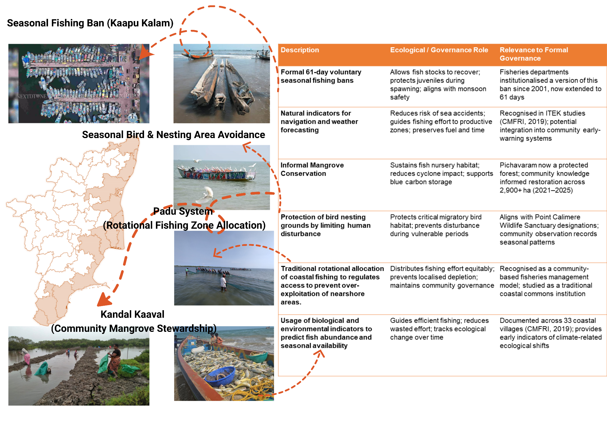
Figure 1: Traditional Knowledge Practices Across the Tamil Nadu Coastline
Sources: CMFRI (2019); Rathakrishnan et al. (2009); Gulf of Mannar field documentation; SSTCN; Tamil Nadu Fisheries Department; CAG research
Mapping What Matters: Participatory Approaches for People-Centred Governance
If effective governance is built on both scientific evidence and community knowledge, the key question is: how do these forms of knowledge come together? One of the most promising approaches is participatory mapping. Unlike conventional maps that primarily depict physical features and administrative boundaries, participatory mapping captures the human dimensions of coastal landscapes, fishing grounds, culturally significant sites, areas vulnerable to erosion, and zones needing restoration, transforming lived experience into spatial information that complements scientific data.
More than a data collection exercise, participatory mapping is a process of knowledge co-production, a platform where scientists, planners, policymakers, and communities build a shared understanding of coastal systems. This reveals aspects of the coast that remain invisible to satellite imagery alone. Coral reefs absorb up to 97% of wave energy, providing billions in coastal protection. Yet the communities that have centuries-long relationships with these systems are rarely included in the decisions that affect them.
When communities move from passive recipients of policy to active partners in governance, decision quality improves, and long-term stewardship strengthens. As coastal regions face intensifying pressures, the most sustainable solutions will emerge when scientific knowledge, traditional knowledge, and community perspectives are woven together, not as competing voices, but as complementary ones.
Every shoreline tells a story of people, place, and generations of knowledge. These stories deserve a place in shaping the decisions that define our coastal future.
---
Add new comment