Introduction
City planning is a vast and intricate field, with various approaches being adopted around the globe. Different cities’ urban development authorities have come up with their own strategies to address specific urban challenges. Until the Town and Country Planning Act of 1971, India had a laissez-faire take on urban development, with minimal government intervention or regulation during the development of an urban space. The introduction of the Town and Country Planning Act and the implementation of the first master plan for Chennai Metropolitan Area in 1976 brought in a more structured approach in terms of governing land use and development in our cities and towns by implementing a set of guidelines and regulations.
In recent years, globally, there has been a growing push towards designing urban spaces that prioritise walkability and community wellbeing, with concepts such as the ‘15-minute cities’ (which ensure that all essential services and amenities are available in close proximity to residences) being endorsed by urban planners. Some well known international cities that have implemented this concept are Bogotá, Barcelona, and Portland.
When it comes to Indian cities, many like Delhi, Pune and Kolkata already exhibit characteristics of 15-minute neighbourhoods with mixed land use that help in reducing travel time. These cities feature a blend of commercial and residential spaces, naturally supporting the goal of reducing motor trips, a key objective of 15-minute cities. However, years of prioritising motorists over pedestrians and cyclists have made even these 15-minute neighbourhoods dangerous and inaccessible for all but motorised vehicles.
Why Does Walkability Matter?
The main idea behind creating walkable neighbourhoods is not necessarily to completely avoid the use of personal vehicles. It is simply to reduce the dependence on private motor vehicles as our main mode of transportation. This model helps to promote healthier lifestyles while reducing congestion and pollution on the road.
There are clear environmental, economic and health benefits to creating walkable neighbourhoods.
- Walkable neighbourhoods help lower carbon emissions from vehicles.
- From an economic perspective, they contribute to reduced transportation costs, create more local job opportunities, and support local businesses.
- In terms of health, walkable areas promote better physical and mental well-being while decreasing the risk of health issues. For instance, a study conducted in Ontario found that people from a walkable neighbourhood weighed 3 kg less than people who lived in a car-dependent area.
Impact of Industrialization on Urban Planning
There is a significant contrast in how cities are planned today compared to our forefathers. Cities of the yesteryears were designed to cater to mobility needs like walking, cycling and animal drawn wagons as these were the primary modes of transportation. Daily necessities, such as markets, religious sites, workplaces and homes, were conveniently located close together. Thus, the streets were generally straight and narrow serving the community’s needs.
Rapid industrialisation, along with the invention of automobiles, transformed city layouts significantly. This period also marked the beginning of rapid development in the transport network, with a notable increase in railways and roads. As a result, it allowed people and goods to move more efficiently around the city, leading to urban sprawl. Urban sprawl occurs when a city expands in an unplanned fashion into its suburbs. These suburbs are often automobile dependent with low public transport options, have low housing density, and single-use zoning.
Industrialisation also caused significant transformations to urban layouts. Urban planners began designing cities to accommodate the growing use of personal automobiles, and allowing room for public transport networks including trains, and trams. The growing reliance on cars and bikes allowed cities to expand beyond the city centre. The combination of urban sprawl and private automobile dependency made our cities shift away from walkability. The roads widened and were now lined with parking lots, causing a decline in walking or cycling. The Comprehensive Mobility Plan for Chennai indicates that there has been a 3% decline in walking and cycling from 2008 to 2018. In Chennai, the trips by non-motorized transport have decreased from 41% in 1970 to 25.1% in 2018.
Current Challenges in Pedestrian Infrastructure: The Case of Chennai
Tamil Nadu is grappling with significant road safety challenges, recording 64,105 accidents in 2022, which was 13.9% of the total incidents nationwide, placing it at the top among all states. Pedestrians remain the most at-risk road users, suffering the second highest fatality rate at 19.5% in road accidents. According to MoRTH (Ministry of Road Transport and Highways), the number of fatalities due to road incidents has risen by 12.7% from 2021 to 2022 in India. A road accident report released by Tamil Nadu State Transport Corporation (TNSTC) states that the pedestrian fatalities increased from 11% in 2019 to 43% in 2022. All of this data directs us to show that pedestrians have become significantly endangered groups of people, with pedestrian deaths continuing to rise year on year. Even though many of our city neighbourhoods have all the right mix for a 15-minute walkable city, these statistics prove that these are ‘walkable’ cities, only in name.
Our problems begin at a very fundamental level. For example, most roads lack adequate provisions for pedestrian infrastructure. In areas where footpaths do exist, they are often obstructed by parked vehicles, shops, street vendors, or garbage, and even planned infrastructure such as garbage skips, and electricity poles, making them unusable. Encroachments and poor maintenance have become significant issues in Chennai. Furthermore, the footpaths that are constructed do not meet accessibility standards, making them difficult for people with disabilities to navigate. As a result of these challenges, pedestrians are compelled to walk on the carriageway, increasing their risk of accidents. This in turn, reduces willingness to walk, and increased dependency on motor vehicles, setting in place a vicious cycle.
Over the past decade few projects have been proposed and even fewer have been implemented to improve pedestrian infrastructure in Chennai. For example, the Pondy Bazar pedestrian plaza, the Mega Street project and Georgetown Redevelopment plan (local area development plan under AMRUT Scheme) are some of the proposed projects; out of these three, only the Pondy Bazar pedestrian plaza has been implemented. Although the pedestrian plaza was initially well-received and effectively served its purpose, over time, pedestrian pathways have become encroached by parked two wheelers. This highlights that even with effective design, the absence of proper enforcement fails to ensure a safe environment for pedestrians.
Additionally, the Mega Street Project, proposed in 2020 to revamp approximately 68 sq. km of Chennai for improved pedestrian infrastructure, has seen little noticeable progress in implementation at the ground level. Even the George Town Local Area Plan is yet to see any implementation at the ground level, and no progress has been documented up to this point.
All of these initiatives concentrate on enhancing a particular stretch of road or a specific local area, targeting a small piece of land. To make a more significant impact in our cities, it's crucial for municipalities and corporations to embrace the development of walkable neighbourhoods by utilising planning tools like local area plans and master plans. Pedestrianisation is an effective tool to increase a city’s livability by improving accessibility, mobility, and safety, that make the city a good place for its citizens.
How can Chennai improve walkability?
With the "Third Master Plan" in Chennai set to be notified by the end of December 2025 or April 2026, now is the perfect time to consider redesigning our cities. The 15-minute city vision first proposed by Professor Carlos Moren in 2016 could become a reality for Chennai, albeit a bit late. Chennai can join those cities that prioritised cars but are going back to create compact neighbourhoods with a focus on pedestrian infrastructure.
The following are some recommendations and pre-requisites to help to create a walkable neighbourhood in Chennai:
Improving NMT infrastructure: Design pedestrian footpaths that are continuous and wide enough to cater to pedestrian footfall. In addition, improve cycling infrastructure. Also create bicycle lanes, designated bicycle parking areas, signage, and street furniture throughout the city to enhance walkability and accessibility.
Create a well-connected street network : Creating interconnected street networks with small blocks will reduce travel time and provide multiple options to connect to the arterial roads. Neighbourhoods with dense interconnected street networks are more likely to have more people walking, cycling, or using public transport. The image below showcases an example from Barcelona, with small blocks featuring interconnected streets which offer various pathways for connectivity. To enhance walking and cycling, the design ensures that interior streets are reserved solely for pedestrians, residents with vehicles and services.
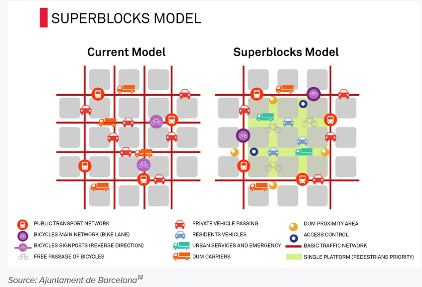
Figure 1: Conceptual diagram of urban superblocks in Barcelona to increase pedestrian space by Ajuntament de Barcelona
Encourage mixed land use: Neighbourhoods with a mixed land use pattern allow different types of services and amenities to coexist side by side. This will help in reducing the travel time to reach these facilities.
Ensuring sufficient population density: A walkable neighbourhood is considered to be more possible when population density within the neighbourhood falls within the range of 5665 to 21844 people per square km. Researchers estimate that this is associated with an 80% probability of walking for transport. This density also creates a sufficient number of residents who will use public transit, support local businesses, and sustain a vibrant mixed-use environment. The population density within the Chennai Metropolitan Area in 2011 was approximately 7,500 people per square kilometer, which falls well within the range. This indicates that we already meet the necessary criteria to establish a 15-minute neighborhood; we just need to implement the infrastructure needed to promote walkability effectively.
Conclusion
Cities are always evolving; with the growth in population and technology, our cities have changed drastically. Especially after industrialization, as motor vehicles became more prevalent, our urban spaces underwent significant transformation. Cities were designed to accommodate vehicles on the road, and slowly the significance of pedestrians on the road started to decrease. Pedestrians who have doggedly continued to walk, remain one of our most vulnerable of road users, with an alarming number of pedestrians losing their lives in India. It is essential that these issues are addressed in the upcoming master plan with a focus on creating more micro-level planning approaches, such as local area planning. By drawing inspiration from 15-minute cities, we can develop our cities that are truly walkable in both spirit and in name.
Add new comment