Did you know that 95 of the world’s hottest cities are in India? No wonder Chennai, being one of the flaming 95, has summers that feel longer and hotter. Globally, the average temperature is already about 1.3°C higher than it was in the 19th century. By 2100 some cities would have seen an average 4°C increase. Indian cities are warming faster than the rest of the world, with studies showing an increase of about 0.53°C per decade.
Heatwaves are not just about discomfort; they're about worsening health conditions, deepened social inequality and strained communities and livelihoods. So why are our cities getting hotter?
It is a well established fact that cities are hotter than surrounding well-vegetated areas. The main cause of this is the urban heat island effect. When natural land and vegetation is replaced by buildings, roads and concrete, these man-made, often concrete surfaces absorb all the solar heat, slowly releasing it back into surrounding areas. The effects of this phenomenon are:
- Higher energy costs: For each degree of increase in ambient temperature rise, the peak electricity demand increases by roughly 3.7% (refer page 12).
- Health risks: When temperature is beyond 35°C (refer page 11) combined with high humidity, it increases heat-related illness and mortality. Even for those who escape the most severe health impacts, heatwaves can still cause discomfort, fatigue, and reduced productivity.
- Pronounced inequality: Low-income neighbourhoods are often densely constructed with little to no tree cover, which means they face the worst impacts.
Chennai’s heightened heatwaves are driven by two particular factors: rapid urbanisation and a growing dependency on private motor vehicles. More concrete structures and roads mean less space for trees and more heat-absorbing surfaces. Global standards suggest about 33% of the city’s area be tree cover. However, Chennai’s tree cover is a very low 5% of the city’s area; although there has been an increase in green cover in the past decade, it is still not sufficient. Coming to the second factor, in Tamil Nadu, the number of vehicles registered increased sharply by 8.4% in 2025. Most of these vehicle registrations are concentrated in the urban areas, namely, Chennai, Chengalpattu, Tiruvallur, Coimbatore, Madurai and Salem districts. The scene we see on the ground is a compounding of these two factors: we are constantly widening roads, often by removing vegetation. Wider roads mean more vehicles on these (known as 'induced traffic'), erasing the local cooling benefits while adding heat from vehicles and concrete structures.
Is there a solution?
As Chennai continues to warm due to rapid urbanisation, finding ways to reduce urban heat is extremely important. Nature-based solutions are one of the most effective and sustainable options in the long run.
One solution is the use of green and blue corridors - made up of plants, trees, parks, ponds, wetlands, lakes and rivers. They help cool cities through shade and evapotranspiration. These corridors have practical effects that can be measured in our daily lives. Street trees can reduce the local air temperature by an average of 3.8°C; a dense canopy can lower perceived temperatures by 10-15°C.
There are several examples across the world that have seen positive results after the implementation of green and blue corridors. In Seoul, Cheonggyecheon restored its urban waterways and saw a reduction in temperature by roughly 3.3–5.9°C compared to roads. By demolishing the Cheonggyecheon expressway, enhancing public transit and implementing car-use restrictions, Seoul city planners were able to reduce vehicle volume. By 2006, the vehicles entering and leaving Cheonggyecheon areas had decreased by 43% and 47% compared to 2002. At the same time, public transit accessibility, measured by a composite index called "MAG", increased by 13.4% between 2002 and 2006. Overall, the combination of all the measures helped reduce traffic around that area.
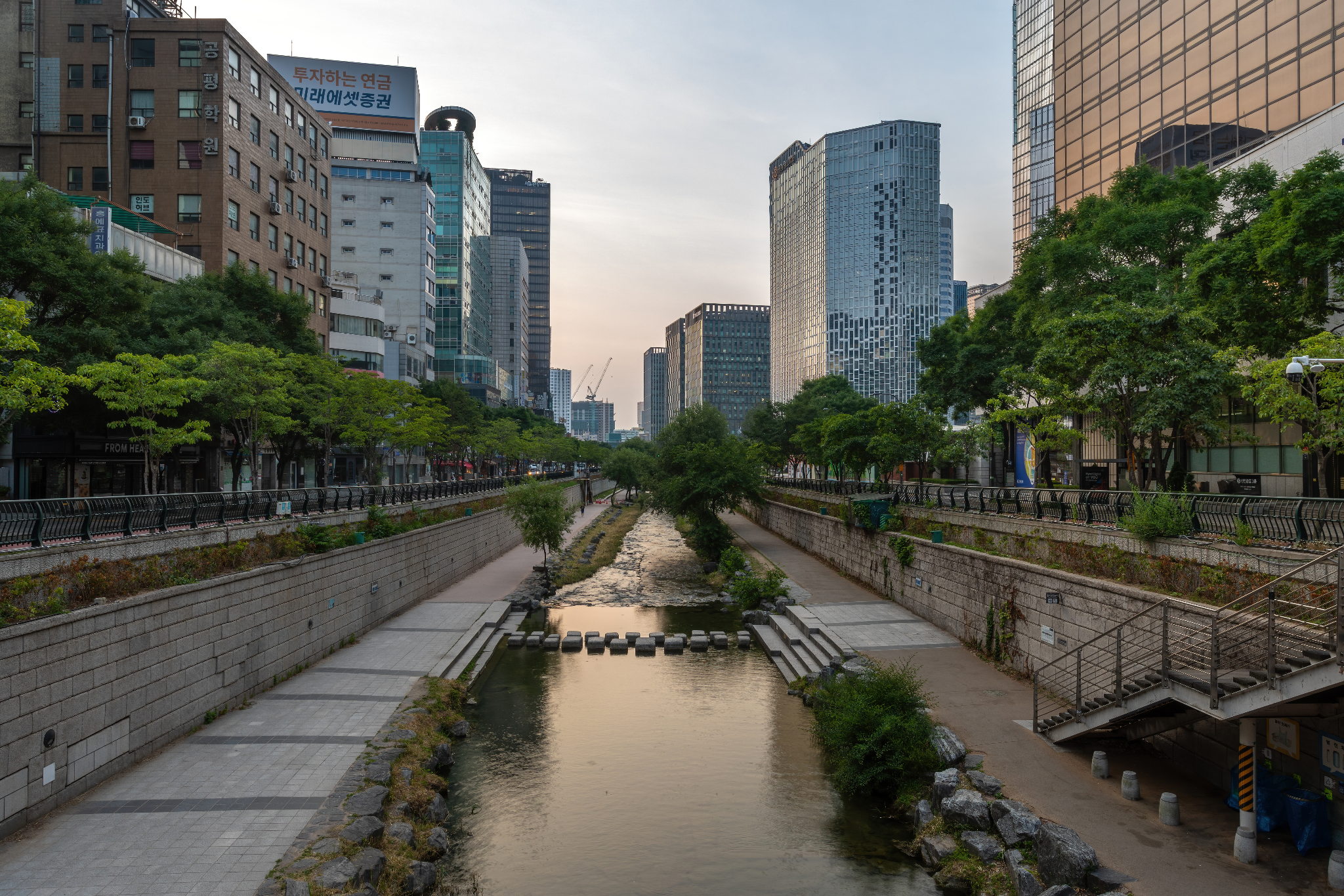
Figure 1: The Cheonggyecheon restoration project in Korea helped lower temperature, improve air quality and increase biodiversity | Wikipedia.
In Medellín, Colombia, after installing 36 corridors by planting 25 lacs plants and 8.8 lacs trees along major roads, the reduction of temperature in certain zones was by 2°C while improving air quality and biodiversity.
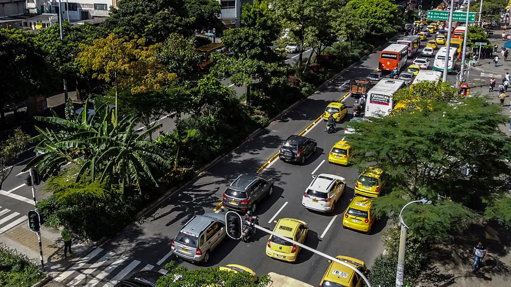
Figure 2: Green cover along major highways helped lower temperatures in Medellín, Colombia | BBC
Another great rule to follow is the 3-30-300 rule, an urban greening used by cities to ensure that nature and its cooling benefits are integrated into the daily lives of all residents. It follows these 3 simple rules:
- Everyone should be able to see at least 3 trees from their home
- Every neighbourhood should have at least 30% tree canopy cover
- Everyone should live within 300 metres of a high-quality public green space suitable for recreational activities.
Importantly, these rules need to be applied equitably and not just in the wealthy neighbourhoods, ensuring that even low-income neighbourhoods are protected by nature.
Another feature that can be added into concrete structures themselves is permeable landscaping. This means that all the material used outdoors should be permeable or use reflective materials to reflect heat, reduce heat absorption and increase groundwater recharge. For example, using lighter-coloured exteriors, green roofs, pocket gardens, reflective roofs, lime washes or white plaster helps to keep the interiors cooler. There are several vernacular elements like shaded verandahs, courtyards, jaali screens and thinnai that were traditionally used to protect our home from extreme heat – it might be time for a revival of these features.
Apart from just heat reduction, planned infrastructure following the above principles can also help:
- Improving air quality and biodiversity.
- Improving mental health by providing space for social life.
- Improving stormwater management and making our city resilient to floods.
Here are some first steps that Chennai’s planners need to make:
- Create a heat map and identify vulnerable areas affected the most by heat waves overlaid with socio-economic data.
- Target tree planting/green corridors and cooling investments (focussing especially in vulnerable areas) where the dependence on intervention from external agencies is the most.
- Protect existing trees and stop routine removal of trees during road widening projects.
- Restore waterways like rivers, canals, ponds and lakes with access to shaded edges.
- Promote walking and cycling along green corridors.
Heat is not just an environmental problem; it’s an urban planning issue that can be reversed even now, even if only to some extent. By prioritising equitable green and blue networks, cooling designs and protection of existing nature, Chennai can cool down, and create a more livable city for everyone.
---
Add new comment