Is Heat Just About Temperature?
As cities confront worsening heat waves, heat risk assessments and planning responses rely heavily on temperature-based indicators, transforming the crisis into a meteorological statistic while overlooking the social realities that shape unequal heat exposure and survival.
However, exposure to the same ambient temperature does not translate into uniform levels of risk. Heat vulnerability is shaped by a combination of socio-economic, occupational, demographic, and infrastructural factors. Outdoor workers engaged in physically intensive labour experience prolonged exposure with limited opportunities for recovery. Households living in densely built or poorly ventilated structures often experience greater indoor heat retention, prolonging thermal stress well beyond daytime hours. Similarly, elderly populations, particularly those living alone or without access to cooling, healthcare, or social support systems, face significantly greater health risks during extreme heat events.
These differences highlight that heat is not experienced solely as a meteorological condition, but as a socially differentiated risk. As a result, identical temperature conditions can produce vastly unequal health, economic, and livelihood outcomes across populations.
This is what our heat data misses.
Understanding of Heat Inequality
Heat inequality in India is not only a result of rising temperatures, but also of unequal access to housing, cooling, healthcare, and urban infrastructure. Nearly 90% of India’s population lives in heat-wave danger zones, while a large share of the workforce remains employed in heat-exposed sectors such as construction, agriculture, and informal labour. Urban slum populations face additional risks due to overcrowded housing, poor ventilation, and limited green cover.
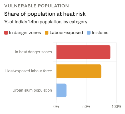
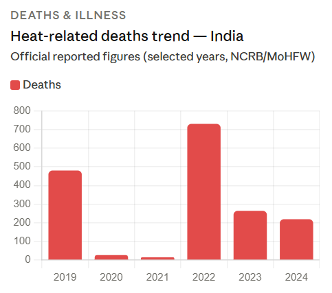
Figure: Population Exposure and Heat-Related Mortality Trends in India
Source: PLOS Climate 2023; ILO 2023; UN-Habitat 2021, NCRB 2022; MoHFW 2023–24; NDMA
At the same time, adaptive capacity remains deeply unequal. Household AC ownership in India stands at around 7–8% nationally and just 1% in rural areas, with the richest 10% accounting for nearly 72% of all AC ownership. Studies also show that urban heatwaves significantly increase mortality risks, particularly among economically vulnerable populations (Borah, Das & Kumar,2026) . These figures highlight that heat is not experienced equally, its impacts are shaped by existing social and economic inequalities, many of which remain poorly measured and inadequately addressed.
From Risk to Resilience: How Planning Decisions Can Close the Heat Data Gap
The challenge of heat inequality is not only that vulnerable populations face greater risks, but that many of these risks remain poorly measured within existing planning systems. Current heat governance continues to rely heavily on temperature thresholds and meteorological alerts, while critical indicators such as housing quality, occupational exposure, access to cooling, indoor heat stress, health vulnerability, and service deficits remain largely absent from urban datasets. As a result, the communities most affected by extreme heat often remain statistically invisible within planning and policy responses.
Urban planning, therefore, has a critical role not only in reducing heat exposure but also in addressing the underlying data gap that shapes unequal responses to heat risk. Integrating social and spatial vulnerability data into planning processes can help cities move from broad temperature-based interventions toward more targeted and equitable heat resilience strategies.
How Urban Planning Can Address the Heat Data Gap
- Integrating Social Vulnerability Indicators into Heat Mapping
Heat-risk assessments should move beyond temperature data to include indicators such as income, housing quality, occupation, age, health conditions, and access to cooling infrastructure at the neighbourhood level. - Developing Localised Heat Vulnerability Mapping
Urban planning processes should incorporate ward- or neighbourhood-scale heat vulnerability maps that identify areas where heat exposure overlaps with poverty, poor housing, limited green cover, and inadequate public services. - Embedding Heat Data into Land Use and Housing Planning
Planning approvals, zoning regulations, and housing policies should integrate thermal performance indicators, ventilation standards, and access to green infrastructure to reduce long-term heat vulnerability. - Incorporating Occupational Heat Exposure into Urban Planning
Labour-intensive and outdoor work sectors remain underrepresented in heat datasets. Planning systems should include occupational exposure data to inform shaded infrastructure, cooling access, and heat-sensitive work regulations. - Linking Heat and Public Health Data Systems
Integrating health surveillance, heat-related illness records, and demographic vulnerability data into urban planning can help identify high-risk populations and strengthen targeted interventions. - Using Data to Guide Equitable Infrastructure Investments
Vulnerability mapping and local heat data should directly inform investments in cooling centres, green spaces, water infrastructure, healthcare access, and climate-resilient public services in high-risk areas.
Closing the heat data gap is therefore not simply a technical exercise in improving climate datasets. It is a planning challenge that requires recognising heat as a socially differentiated urban risk. Without integrating vulnerability data into planning systems, cities risk continuing to design heat responses that measure temperature accurately, but fail to protect the populations most exposed to its impacts.
---
Add new comment